
GEOLOGICAL CARBON FLOWS PART-2
Tambonthangchai Posted by: chaamjamal on: January 20, 2021
THIS POST IS A PRESENTATION OF SOURCES OF CARBON TRANSFERS FROM THE MANTLE TO THE SURFACE BY WAY OF SEEPAGE, HYDROTHERMAL VENTS, HYDROTHERMAL PLUMES, SUBMARINE VOLCANISM, AND ASSOCATED GEOLOGICAL ACTIVITY. THE CONTEXT OF THIS STUDY IS ANTHROPOGENIC GLOBAL WARMING (AGW) WHERE FOSSIL FUEL EMISSIONS ARE ASSUMED TO BE THE SOLE SOURCE OF CARBON EXTERNAL TO THE CARBON CYCLE.
THE ANALYSIS IS PRESENTED IN TWO PARTS. PART-1 IS A SUMMARY AND INTERPRETATION OF THE DATA PRESENTED IN PART-2 IN THE CONTEXT OF AGW CLIMATE CHANGE: PART-2 IS A LITERATURE REVIEW ON THE SUBJECT OF GEOLOGICAL FLOWS THAT TRANSFER CARBON FROM THE MANTLE TO THE SURFACE. THE GEOLOGICAL FLOWS PRESENTED BELOW INCLUDE HYDROCARBON SEEPS, SUBMARINE VOLCANISM, AND HYDROTHERMAL VENTS AND PLUMES.
THIS POST IS A CONTINUATION OF STUDIES PRESENTED IN RELATED POSTS LINKED BELOW WHERE THE ASSUMED CAUSAL CONNECTION BETWEEN FOSSIL FUEL EMISSIONS AND ATMOSPHERIC COMPOSITION IS TESTED.
LINK#1: https://tambonthongchai.com/2020/11/21/the-case-against-fossil-fuels/
LINK#2: https://tambonthongchai.com/2020/12/29/climate-scientist-explains-the-carbon-budget/
LINK#3: https://tambonthongchai.com/2020/11/11/annual-changes-in-mlo-co2/
LINK#4: https://tambonthongchai.com/2019/08/27/carbonflows/ .

PART-1: THE CASE AGAINST FOSSIL FUELS AS A SOLE SOURCE OF VIRGIN CARBON THAT HAS NO 13C or 14C ISOTOPES AND THAT IS NOT A PART OF THE CARBON CYCLE.
In a related post: LINK: https://tambonthongchai.com/2020/07/31/planetary-environmentalism-in-the-anthropocene/ we note that although climate change is understood and preached on a planetary scale, humans, along with the rest of nature and the part of the planet where we live are rather insignificant in the planetary context. To quote the related post: {The crust of the planet where we live contains 0.201% of the planet’s carbon some of which appear as carbon lifeforms such as humans, flora, and fauna and some of which appear as long dead life forms turned into fossil fuels. Yet another portion, not generally mentioned, is the continued physcal leakage of carbon from the inner planet to the crust.}
The other 99.8% of the carbon inventory of the planet is in the inner planet consisting of the mantle and core. This inner planet is the sole source of carbon for the planet. It is from this huge inventory that carbon has been continually leaking out to the crust where the carbon has created carbon life forms, an atmosphere that contans CO2, and long dead fossilized carbon life forms with their carbon remains used as fuel by the current life forms. The narrow and single minded focus on fossil fuels as the only source of carbon that can change atmospheric composition is inconsistent with the greater source of geological carbon under the ocean.
The issue in this post is that fossil fuel combustion by the industrial economy as the sole source of CO2 that can explain observed changes in atmospheric composition is inconsistent with natural geological flows of carbon from the ocean to the atmosphere. Climate science does take volcanic activity into consideration but these analyses are made only when a periodic temperature anomaly needs to be explained as for example the ETCW (Early 20th Century Warming anomaly) and only with land volcanoes. More than 80% of our volcanoes are under the ocean and these submarine volcanoes are more active than land volcanoes. Our volcanic activity is mostly submarine. The consideration of carbon sources other than fossil fuel emissions is made necessary by the absence of empirical evidence that can explain changes in atmospheric CO2 concentration exclusively in terms of fossil fuel emissions. This gap in climate science is presented in a related post: LINK: https://tambonthongchai.com/2020/12/29/climate-scientist-explains-the-carbon-budget/
IN OTHER RELATED POSTS WE DESCRIBE (1) OCEAN ACIDIFICATION IN TERMS OF THE ABILITY OF THE OCEAN TO ACIDIFY ITSELF: LINK: https://tambonthongchai.com/2020/08/14/ocean-volcanism/ AND IN TERMS OF THE PETM EVENT IN PALEO CLIMATOLOGY WHRE WE FIND THAT GEOLOGICAL CARBON HAD ACIDIFIED THE OCEAN AND CAUSED ATMOSPHERIC CO2 TO RISE: LINK: https://tambonthongchai.com/2020/03/20/an-atmosphere-bias-part-2/
HERE WE PRESENT A LITERATURE SURVEY ON THE SUBJECT OF GEOLOGICAL SOURCES OF CARBON FLOW FROM THE OCEAN TO THE ATMOSPHERE. OFFSHORE SEEPS, SUBMARINE VOLCANISM, AND HYDROTHERMAL VENTS AND PLUMES ARE STUDIED AS CANDIDATES FOR GEOLOGICAL SOURCES OF CARBON THAT CAN CHANGE ATMOSPHERIC COMPOSITION.

2A: OFFSHORE SEEPS
MacDonald, Ian R., et al. “Remote sensing inventory of active oil seeps and chemosynthetic communities in the northern Gulf of Mexico.” (1996): 27-37. We compiled locations of probable oil slicks from interpretation of a Space Shuttle photograph, a Landsat Thematic Mapper scene, three European Radar Satellite scenes, and collections of floating oil and observations of sea floor seeps from submarines. These locations were ranked according to recurrence of evidence for natural oil seepage among the various data sets. As a result, we have verified 43 biological communities that depend on hydrocarbon seeps and 63 locations where remote sensing data indicate that sea floor sources are capable of producing perennial oil slicks. Monitoring individual seeps over time contributes to understanding the natural loading of hydrocarbons in the marine environment. The seeps also form a natural test bed for development of sensors and techniques to detect oil floating on the sea. Remote detection of natural seepage extends the probable range of chemosynthetic communities dependent on hydrocarbon seepage in the northern Gulf of Mexico. This technique for detecting areas of macroseepage is potentially applicable to hydrocarbon basins in which oil production is in an earlier stage of development than the Gulf of Mexico.

MacDonald, I. R., et al. “Transfer of hydrocarbons from natural seeps to the water column and atmosphere.” Geofluids 2.2 (2002): 95-107. Results from surface geochemical prospecting, seismic exploration and satellite remote sensing have documented oil and gas seeps in marine basins around the world. Seeps are a dynamic component of the carbon cycle and can be important indicators for economically significant hydrocarbon deposits. The northern Gulf of Mexico contains hundreds of active seeps that can be studied experimentally with the use of submarines and Remotely Operated Vehicles (ROV). Hydrocarbon flux through surface sediments profoundly alters benthic ecology and seafloor geology at seeps. In water depths of 500–2000m, rapid gas flux results in shallow, metastable deposits of gas hydrate, which reduce sediment porosity and affect seepage rates. This paper details the processes that occur during the final, brief transition — as oil and gas escape from the seafloor, rise through the water and dissolve, are consumed by microbial processes, or disperse into the atmosphere. The geology of the upper sediment column determines whether discharge is rapid and episodic, as occurs in mud volcanoes, or more gradual and steady, as occurs where the seep orifice is plugged with gas hydrate. In both cases, seep oil and gas appear to rise through the water in close proximity instead of separating. Chemical alteration of the oil is relatively minor during transit through the water column, but once at the sea surface its more volatile components rapidly evaporate. Gas bubbles rapidly dissolve as they rise, although observations suggest that oil coatings on the bubbles inhibit dissolution. At the sea surface, the floating oil forms slicks, detectable by remote sensing, whose origins are laterally within ∼1000 m of the seafloor vent. This contradicts the much larger distance predicted if oil drops rise through a 500 m water column at an expected rate of ∼0.01 m s−1 while subjected to lateral currents of ∼0.2 m s−1 or greater. It indicates that oil rises with the gas bubbles at speeds of ∼0.15 m s−1 all the way to the surface. Hydrocarbon migration through shallow marine sediment is a widespread phenomenon on the continental margins throughout the world. Over geological time, the hydrocarbon seep process returns large amounts of carbon from thermogenic sources to the biosphere, but the ‘best’ estimate for global input is 2.5E8 (250 million) L per year of oil entering the world oceans from natural seepage. However, this estimate was based on relatively few data from real‐world seeps. Satellite remote sensing imagery readily detects layers of floating oil that form over active seeps (Espedal & Wahl 1999), providing a means to estimate the rates at which seeps are flowing (MacDonald et al. 1993) and to survey the numbers of hydrocarbon seeps across oil‐producing regions (Kornacki et al. 1994; MacDonald et al. 1996). The Gulf of Mexico contributes a large fraction of the global total estimated by Kvenvolden & Harbaugh (1983), it is probable that their estimate should be revised upwards. A better understanding of seep geology and geochemistry will improve the accuracy of new estimates of global and regional seep rates. In particular, factors that cause seepage rates to vary over time need to be examined. Seeps form where migration is rapid and ongoing. Organic enrichment from the oil and gas produces profound alteration of surface sediments, including the precipitation of carbonates and colonization by dense aggregations of chemosynthetic fauna.
Mityagina, Marina, and Olga Lavrova. “Oil Slicks from Natural Hydrocarbon Seeps in the Southeastern Black Sea, Their Drift and Fate as Observed via Remote Sensing.” IGARSS 2018-2018 IEEE International Geoscience and Remote Sensing Symposium. IEEE, 2018. The paper discusses our studies of oil pollution due to natural hydrocarbon seeps on the seafloor in the South-Eastern Black Sea. The patterns of surface oil pollution of the South-Eastern Black Sea are analyzed and described. Trajectories of oil slicks from seabed seepages are analyzed on the base of satellite remote sensing data for 2010-2017. The quantitative assessment of inter-annual, seasonal and spatial variability of natural oil pollution of the region of interest is performed. Maps of oil pollution risks of sea surface and shores in the South-Eastern Black Sea are created. The precise estimation of the actual seafloor source location is made on the base of satellite data. The impact of dynamic and circulation processes and natural factors (current meandering, vortical activity, and wind patterns) on the stretching, spread, and disappearance of oil films is discussed.
Kvenvolden, K. A., and C. K. Cooper. “Natural seepage of crude oil into the marine environment.” Geo-marine letters 23.3-4 (2003): 140-146. Recent global estimates of crude-oil seepage rates suggest that about 47% of crude oil currently entering the marine environment is from natural seeps, whereas 53% results from leaks and spills during the extraction, transportation, refining, storage, and utilization of petroleum. The amount of natural crude-oil seepage is currently estimated to be 600,000 metric tons per year, with a range of uncertainty of 200,000 to 2,000,000 metric tons per year. Thus, natural oil seeps may be the single most important source of oil that enters the ocean, exceeding each of the various sources of crude oil that enters the ocean through its exploitation by humankind.
D’souza, N. A., et al. “Elevated surface chlorophyll associated with natural oil seeps in the Gulf of Mexico.” Nature Geoscience 9.3 (2016): 215-218. Natural hydrocarbon seeps occur on the sea floor along continental margins, and account for up to 47% of the oil released into the oceans. Hydrocarbon seeps are known to support local benthic productivity2, but little is known about their impact on photosynthetic organisms in the overlying water column. Here we present observations with high temporal and spatial resolution of chlorophyll concentrations in the northern Gulf of Mexico using in situ and shipboard flow-through fluorescence measurements from May to July 2012, as well as an analysis of ocean-colour satellite images from 1997 to 2007. All three methods reveal elevated chlorophyll concentrations in waters influenced by natural hydrocarbon seeps. Temperature and nutrient profiles above seep sites suggest that nutrient-rich water upwells from depth, which may facilitate phytoplankton growth and thus support the higher chlorophyll concentrations observed. Because upwelling occurs at natural seep locations around the world1,2,3, we conclude that offshore hydrocarbon seeps, and perhaps other types of deep ocean vents and seeps at depths exceeding 1,000 m, may influence biogeochemistry and productivity of the overlying water column.
PART-2B: SUBMARINE VOLCANISM
McBirney, Alexander R. “Factors governing the nature of submarine volcanism.” Bulletin volcanologique 26.1 (1963): 455-469. Examination of the volumetric expansion of vesiculating water vapor at temperatures and pressure corresponding to those of basaltic and rhyolitic magmas erupting under various depths of sea water indicates that explosive ash formation is unlikely at depths greater than 500 meters. Rhyolitic magmas could produce ash at greater depths, but only if the water content were greatly enriched. Sills are likely to be more common than surface lava flows in level area of weakly consolidated sediments. Breaching of the sedimentary layer and the growth of seamounts may be related to block faulting or seismically induced slumping of the sedimentary blanket on the slopes of volcanic domes. Conditions favor transport of hot hyaloclastites in density currents on the slopes of sea mounts and may account for archipelagic aprons.
Wakita, H., et al. “Origin of methane-rich natural gas in Japan: formation of gas fields due to large-scale submarine volcanism.” Applied geochemistry 5.3 (1990): 263-278. Eighty-seven samples of CH4-rich natural gas were collected from commercial gas and oil wells in Japan. The3He/4He and4He/20Ne ratios, chemical composition of major, minor and trace components (CH4, C2H6, C3H8, CO2, N2, O2, Ar, He, Ne and H2), and the C isotope composition of CH4 are reported. Most3He/4He ratios of natural gases in the forearc regions are as low as (1–4) × 10−7 and are comparable to those from large gas reservoirs in other parts of the world, suggesting that the CH4 there has a biogenic origin. In contrast, the3He/4He ratios of samples from gas reservoirs in the “Green Tuff” region along the Japan Sea vary considerably: high ratios are observed for gases from volcaniclastic reservoirs in the deeper zone, and low ratios are found in shallow reservoirs of sedimentary rocks. The highest3He/4He ratio, (9.37 ± 0.34) × 10−6, is equivalent to the highest value in the subduction zone. The high4He/20Ne ratios observed in most samples suggest that there is no significant atmospheric contamination. An overall regularity between3He/4He ratios and δ13CCH4 values is observed for Japanese natural gases. The δ13CCH4 value of gas with a high3He/4He ratio reaches about −35‰, and that of gas with a low ratio is about −75‰. Total C to3He ratios (ΣC/3He) vary over a wide range (6 × 10⁸−>9 × 10¹²), but those of gases in volcaniclastic reservoirs are in a rather narrow range with a value of ∼2 × 10⁹, coinciding with that of a mantle reservoir. The relation between the observed3He/4He ratios and δ13CCH4 values of gases, together with their ΣC/3He ratios, suggests that CH4-rich gases in volcaniclastic reservoirs are a mixture of gases from two sources, magmatic and biogenic. The formation of gas reservoirs with high3He/4He ratios may be attributed to large-scale submarine volcanism that occurred in the Middle Miocene. Gas separation from volcaniclastic rocks is expected to have occurred during the process of sea water-rock interaction at a high temperature over a long period in a submarine environment. The Middle Miocene volcanic episode which occurred under extensional stress was quite different from the present arc volcanism, and is thought to have been closely related to the opening of the Japan Sea. (LINK TO MID MIOCENE POST: https://tambonthongchai.com/2019/01/17/miocene/ )
Williams, Stanley N., et al. “Global carbon dioxide emission to the atmosphere by volcanoes.” Geochimica et Cosmochimica Acta 56.4 (1992): 1765-1770. Global emission of carbon dioxide by subaerial volcanoes is calculated, using from volcanic gas analyses and SO2 flux, to be from passive degassing and from eruptions. Volcanic CO2 presently represents only 0.22% of anthropogenic emissions but may have contributed to significant “greenhouse” effects at times in Earth history. Models of climate response to CO2 increases may be tested against geological data.
Bluth, G. J. S., et al. “The contribution of explosive volcanism to global atmospheric sulphur dioxide concentrations.” Nature 366.6453 (1993): 327-329. SULPHUR dioxide from volcanic eruptions may have a significant effect on the Earth’s climate and atmospheric chemistry, and it is therefore important to quantify outgassing rates for all types of volcanic activity. Non-explosive volcanoes (for example, Mount Etna) outgas at relatively constant rates, providing an annual flux of about 9 million tons (Mt) SO2 (ref. 1). By contrast, the outgassing from volcanoes prone to explosive eruptions (such as Mount Pinatubo) is sporadic and much more difficult to quantify. The total annual volcanic SO2 flux is therefore poorly constrained, with ground-based estimates1–8 ranging from 1.5 to 50 Mt–up to onequarter of the estimated current anthropogenic contribution. The Total Ozone Mapping Spectrometer aboard the NASA satellite Nimbus 7 recorded SO2emissions from explosive eruptions from November 1978 to May 1993. We use these data to show that the annual flux from explosive volcanism is of the order of 4 Mt SO2, less than half of the non-explosive output. Thus it seems that the total volcanic emission of SO2 to the Earth’s atmosphere is about 13 Mt yr−1, which is only 5–10% of the current anthropogenic flux.
Charlou, Jean‐Luc, and Jean‐Pierre Donval. “Hydrothermal methane venting between 12° N and 26° N along the Mid‐Atlantic Ridge.” Journal of Geophysical Research: Solid Earth 98.B6 (1993): 9625-9642. Hydrographic surveys along the Mid‐Atlantic Ridge (MAR) between 12°N and 26°N, carried out from 1984 to 1990, show a variable pattern of CH4‐rich water column plumes. The vertical distribution of CH4 at stations located every 20–40 km is presented along this 1200‐km‐long section of the MAR. CH4 venting is clearly demonstrated. CH4‐enriched fluids rise from vents as plumes; spreading is confined to the axial valley due to the topography of the MAR. CH4 contents from 45 nmol to 675 nmol/kg are measured in the buoyant plumes above the two active hydrothermal sites (MARK 23°N; TAG 26°N) known at present, whereas CH4 anomalies up to 3.6 nmol/kg are typically observed in plumes emitted either on the inner floor, on the walls, and/or at the top of the rift mountains along the studied ridge section. CH4 concentrations (45 μmol to 144 μmol/kg) in MARK and TAG vent fluids are of the same order of magnitude as those found in the East Pacific Rise fluids. Even though CH4 is known to be unstable with respect to oxidation by dissolved oxygen, and in spite of its microbial oxidation in plumes, these results confirm CH4 to be a good indicator to track hydrothermal plumes and to map the variation of hydrothermal activity along mid oceanic ridges. Moreover, between 12° and 26°N along the MAR, CH4 results show that while hydrothermal activity is present everywhere along the ridge, it is predominant near fracture zones (FZ) (Kane FZ, 15°20′N FZ). Comparison of CH4 tracer with total dissolvable manganese (TDM) tracer in plumes allows us to differentiate subseafloor hydrothermal processes. The high TDM/CH4 found above TAG and MARK areas is indicative of basalt‐seawater interaction, while at 15°N the low TDM/CH4 provides evidence of fluid circulation in ultrabasic rocks. CH4 data confirm the association between mantle degassing, hydrothermal activity, and serpentinization along this 12°–26°N section of the Mid‐Atlantic Ridge.
Frey, Frederic A., et al. “Origin and evolution of a submarine large igneous province: the Kerguelen Plateau and Broken Ridge, southern Indian Ocean.” Earth and Planetary Science Letters 176.1 (2000): 73-89. Oceanic plateaus form by mantle processes distinct from those forming oceanic crust at divergent plate boundaries. Eleven drillsites into igneous basement of Kerguelen Plateau and Broken Ridge, including seven from the recent Ocean Drilling Program Leg 183 (1998–99) and four from Legs 119 and 120 (1987–88), show that the dominant rocks are basalts with geochemical characteristics distinct from those of mid-ocean ridge basalts. Moreover, the physical characteristics of the lava flows and the presence of wood fragments, charcoal, pollen, spores and seeds in the shallow water sediments overlying the igneous basement show that the growth rate of the plateau was sufficient to form subaerial landmasses. Most of the southern Kerguelen Plateau formed at ∼110 Ma, but the uppermost submarine lavas in the northern Kerguelen Plateau erupted during Cenozoic time. These results are consistent with derivation of the plateau by partial melting of the Kerguelen plume. Leg 183 provided two new major observations about the final growth stages of the Kerguelen Plateau. 1: At several locations, volcanism ended with explosive eruptions of volatile-rich, felsic magmas; although the total volume of felsic volcanic rocks is poorly constrained, the explosive nature of the eruptions may have resulted in globally significant effects on climate and atmospheric chemistry during the late-stage, subaerial growth of the Kerguelen Plateau. 2: At one drillsite, clasts of garnet–biotite gneiss, a continental rock, occur in a fluvial conglomerate intercalated within basaltic flows. Previously, geochemical and geophysical evidence has been used to infer continental lithospheric components within this large igneous province. A continental geochemical signature in an oceanic setting may represent deeply recycled crust incorporated into the Kerguelen plume or continental fragments dispersed during initial formation of the Indian Ocean during breakup of Gondwana. The clasts of garnet–biotite gneiss are the first unequivocal evidence of continental crust in this oceanic plateau. We propose that during initial breakup between India and Antarctica, the spreading center jumped northwards transferring slivers of the continental Indian plate to oceanic portions of the Antarctic plate.
Gamo, Toshitaka, et al. “Discovery of a new hydrothermal venting site in the southernmost Mariana Arc: Al-rich hydrothermal plumes and white smoker activity associated with biogenic methane.” Geochemical Journal 38.6 (2004): 527-534. This paper reports a series of studies leading to the discovery of a submarine hydrothermal field (called Nakayama Field) at an arc seamount (12°43′N, 143°32′E) in the southernmost part of the Mariana Trough, western Pacific Ocean. We first detected hydrothermal plumes characterized by water column anomalies of temperature, light transmission, Mn, Fe, Al, O2, CH4, and δ13C of CH4 above the summit caldera of the seamount. Then deep-tow camera surveys confirmed the existence of hydrothermal activity inside the caldera, and an ROV dive finally discovered white smoker-type fluid venting associated with vent fauna. A high concentration of aluminum in the plume and white smoker-type emissions imply acidic hydrothermal activity similar to that observed at the DESMOS Caldera in the eastern Manus Basin, Papua New Guinea. Anomalously low δ13C (CH4) of −38‰ of a vent fluid sample compared to other arc hydrothermal systems along the Izu-Bonin and Mariana Arcs suggests an incorporation of biogenic methane based on a subsurface microbial ecosystem
Kump, Lee R., and Mark E. Barley. “Increased subaerial volcanism and the rise of atmospheric oxygen 2.5 billion years ago.” Nature 448.7157 (2007): 1033-1036. The hypothesis that the establishment of a permanently oxygenated atmosphere at the Archaean–Proterozoic transition (∼2.5 billion years ago) occurred when oxygen-producing cyanobacteria evolved is contradicted by biomarker evidence for their presence in rocks 200 million years older. To sustain vanishingly low oxygen levels despite near-modern rates of oxygen production from ∼2.7–2.5 billion years ago thus requires that oxygen sinks must have been much larger than they are now. Here we propose that the rise of atmospheric oxygen occurred because the predominant sink for oxygen in the Archaean era—enhanced submarine volcanism—was abruptly and permanently diminished during the Archaean–Proterozoic transition. Observations3,4,5 are consistent with the corollary that subaerial volcanism only became widespread after a major tectonic episode of continental stabilization at the beginning of the Proterozoic. Submarine volcanoes are more reducing than subaerial volcanoes, so a shift from predominantly submarine to a mix of subaerial and submarine volcanism more similar to that observed today would have reduced the overall sink for oxygen and led to the rise of atmospheric oxygen. (BLOGGER’S NOTE: ATMOSPHERIC COMPOSITION DERIVED FROM SUBMARINE VOLCANISM).
Carazzo, G., E. Kaminski, and S. Tait. “On the rise of turbulent plumes: Quantitative effects of variable entrainment for submarine hydrothermal vents, terrestrial and extra terrestrial explosive volcanism.” Journal of Geophysical Research: Solid Earth 113.B9 (2008). The maximum height reached by a turbulent plume rising in a stratified environment is a key tool to estimate the flux released at its source, particularly for large‐scale flows because flux can often be very hard to measure directly. This height is known to be mainly controlled by the stratification of the ambient fluid, source buoyancy flux, and the efficiency of turbulent mixing between the plume and the external fluid. The latter effect has been only superficially explored in spite of its fundamental control on the dynamics. Here we show that commonly used one‐dimensional models incorporating a constant entrainment coefficient do not provide satisfying predictions. We propose a new model allowing for variable entrainment which gives excellent predictions of maximum heights reached by laboratory plumes in stratified environments. We then apply our formalism to natural plumes produced by explosive volcanic eruptions under terrestrial, paleo‐Martian, and Venusian conditions and by submarine hydrothermal activity at mid‐ocean ridges. Source mass discharge rates deduced from maximum volcanic column heights for terrestrial eruptions are found to be greater than those estimated with the commonly used constant entrainment parameterization by a factor of 2. In the paleo‐Martian atmosphere, existing models overestimate plume heights by 14–27%. In the current atmosphere of Venus, the maximum height reached by a volcanic plume is also found to be smaller than previously estimated for large eruption rates. The source heat flux released by the TAG field (Atlantic Ocean) deduced from several submarine hydrothermal plumes is found greater by a factor 3 with our model. {BACKGROUND INFORMATION: Turbulent jets and plumes play a fundamental role in a large variety of natural phenomena. Understanding the dynamics of plumes issuing from industrial chimneys or those generated by forest or oil fires is a major goal for environmental science. These large‐scale plumes are able to transport toxic gas and fine particles into the high atmosphere}. High speed turbulent jets in nature are those produced during explosive volcanic eruptions. Volcanic eruptions produce a dense mixture of hot ash and gases that can reach altitudes of several tens of kilometers in the atmosphere or collapse to produce pyroclastic flows [Wilson, 1976]. The prediction of column behavior is also fundamental to evaluating climatic impacts and hazards linked to these eruptions. Theoretical models have been proposed to describe the physics of turbulent plumes. These models revealed that plume dynamics are mainly controlled by the efficiency of entrainment of surrounding fluid by turbulent shear at the edges of the flow.
Lupton, John, et al. “Venting of a separate CO2‐rich gas phase from submarine arc volcanoes: Examples from the Mariana and Tonga‐Kermadec arcs.” Journal of Geophysical Research: Solid Earth 113.B8 (2008). Submersible dives on 22 active submarine volcanoes on the Mariana and Tonga‐Kermadec arcs have discovered systems on six of these volcanoes that, in addition to discharging hot vent fluid, are also venting a separate CO2‐rich phase either in the form of gas bubbles or liquid CO2 droplets. One of the most impressive is the Champagne vent site on NW Eifuku in the northern Mariana Arc, which is discharging cold droplets of liquid CO2 at an estimated rate of 23 mol CO2/s, about 0.1% of the global mid‐ocean ridge (MOR) carbon flux. Three other Mariana Arc submarine volcanoes (NW Rota‐1, Nikko, and Daikoku), and two volcanoes on the Tonga‐Kermadec Arc (Giggenbach and Volcano‐1) also have vent fields discharging CO2‐rich gas bubbles. The vent fluids at these volcanoes have very high CO2 concentrations and elevated C/3He and δ13C (CO2) ratios compared to MOR systems, indicating a contribution to the carbon flux from subducted marine carbonates and organic material. Analysis of the CO2 concentrations shows that most of the fluids are undersaturated with CO2. This deviation from equilibrium would not be expected for pressure release degassing of an ascending fluid saturated with CO2. Mechanisms to produce a separate CO2‐rich gas phase at the seafloor require direct injection of magmatic CO2‐rich gas. The ascending CO2‐rich gas could then partially dissolve into seawater circulating within the volcano edifice without reaching equilibrium. Alternatively, an ascending high‐temperature, CO2‐rich aqueous fluid could boil to produce a CO2‐rich gas phase and a CO2‐depleted liquid. These findings indicate that carbon fluxes from submarine arcs may be higher than previously estimated, and that experiments to estimate carbon fluxes at submarine arc volcanoes are merited. Hydrothermal sites such as these with a separate gas phase are valuable natural laboratories for studying the effects of high CO2 concentrations on marine ecosystems.
Huybers, Peter, and Charles Langmuir. “Feedback between deglaciation, volcanism, and atmospheric CO2.” Earth and Planetary Science Letters 286.3-4 (2009): 479-491. An evaluation of the historical record of volcanic eruptions shows that **subaerial volcanism increased globally by two to six times above background levels between 12 ka and 7 ka, during the last deglaciation**. Increased volcanism occurs in deglaciating regions. Causal mechanisms could include an increase in magma production owing to the mantle decompression caused by ablation of glaciers and ice caps or a more general pacing of when eruptions occur by the glacial variability. A corollary is that ocean ridge volcanic production should decrease with the rising sea level during deglaciation, with the greatest effect at slow spreading ridges. CO2 output from the increased subaerial volcanism appears large enough to influence glacial/interglacial CO2 variations. We estimate subaerial emissions during deglaciation to be between 1000 and 5000 Gt of CO2 above the long term average background flux, assuming that emissions are proportional to the frequency of eruptions. After accounting for equilibration with the ocean, this additional CO2 flux is consistent in timing and magnitude with ice core observations of a 40 ppm increase in atmospheric CO2 concentration during the second half of the last deglaciation. Estimated decreases in CO2 output from ocean ridge volcanoes compensate for only 20% of the increased subaerial flux. If such a large volcanic output of CO2 occurs, then volcanism forges a positive feedback between glacial variability and atmospheric CO2 concentrations: deglaciation increases volcanic eruptions, raises atmospheric CO2, and causes more deglaciation. Such a positive feedback may contribute to the rapid passage from glacial to interglacial periods. Conversely, waning volcanic activity during an interglacial could lead to a reduction in CO2 and the onset of an ice age. Whereas glacial/interglacial variations in CO2 are generally attributed to oceanic mechanisms, it is suggested that the vast carbon reservoirs associated with the solid Earth may also play an important role.
Resing, Joseph A., et al. “Chemistry of hydrothermal plumes above submarine volcanoes of the Mariana Arc.” Geochemistry, Geophysics, Geosystems 10.2 (2009). Fifty submarine volcanoes of the Mariana Arc, covering 1200 km from 13.5°N to 23.2°N, were surveyed for hydrothermal activity. Of these 50 volcanoes, eight showed limited evidence of hydrothermal activity, while another 10 volcanoes displayed intense, chemically rich, hydrothermal plumes that allow detailed chemical characterization and insight into the hydrothermal activity forming the fluids that generate the plumes. The most active volcanoes exhibit a wide range of CO2 to pH relationships, from the venting of acid‐rich fluids, to CO2‐rich fluids, to fluids rich in alkalinity and CO2. These pH‐CO2‐alkalinity relationships are partially responsible for the wide range of Fe:Mn (3 to 32) observed at the different volcanoes. This chemical heterogeneity is further manifest in a wide range of CO2:3He (3 × 10⁹ to 55 × 109), indicating that for all but one, >80% of the CO2 venting from these volcanoes has a slab source. The helium, by contrast, has an upper mantle isotopic signature. The range of chemical conditions suggests that these volcanoes occupy various states of eruptive evolution ranging from ongoing magmatic activity to highly evolved hydrothermal systems.
Lupton, John, et al. “Active hydrothermal discharge on the submarine Aeolian Arc.” Journal of Geophysical Research: Solid Earth 116.B2 (2011). In November 2007 we conducted a water column and seafloor mapping study of the submarine volcanoes of the Aeolian Arc in the southern Tyrrhenian Sea aboard the R/V Urania. On 26 conductivity‐temperature‐depth casts and tows we measured temperature, conductivity, pressure, and light scattering and also collected discrete samples for helium isotopes, methane, and pH. The 3He/4He isotope ratio, an unambiguous indicator of hydrothermal input, showed a clear excess above background at 6 of the 10 submarine volcanoes surveyed. Marsili seamount had the highest anomaly, where the 3He/4He ratio reached a δ3He value of 23% at 610 m depth compared with background values of ∼5%. Smaller but distinct δ3He anomalies occurred over Palinuro, Enarete, Eolo, Sisifo, and Secca del Capo. Although hydrothermal emissions are known to occur offshore of some Aeolian subaerial volcanoes, and hydrothermal deposits have been sampled throughout the arc, our results are the first to confirm active discharge on Marsili, Enarete, Eolo, Sisifo, and Secca del Capo. Samples collected over Lametini, Filicudi North, Alicudi North, and Alcione had δ3He near the regional background values, suggesting either absence of, or very weak, hydrothermal activity on these seamounts. Hydrocasts between the volcanoes revealed a consistent δ3He maximum between 11% and 13% at 2000 m depth throughout the SE Tyrrhenian Sea. The volcanoes of the Aeolian arc and the Marsili back arc, all <1000 m deep, cannot contribute directly to this maximum. This deep 3He excess may be a remnant of tritium decay or may have been produced by an unknown deep hydrothermal source.
Gaillard, Fabrice, Bruno Scaillet, and Nicholas T. Arndt. “Atmospheric oxygenation caused by a change in volcanic degassing pressure.” Nature 478.7368 (2011): 229-232. The Precambrian history of our planet is marked by two major events: a pulse of continental crust formation at the end of the Archaean eon and a weak oxygenation of the atmosphere (the Great Oxidation Event) that followed, at 2.45 billion years ago. This oxygenation has been linked to the emergence of oxygenic cyanobacteria1,2 and to changes in the compositions of volcanic gases3,4, but not to the composition of erupting lavas—geochemical constraints indicate that the oxidation state of basalts and their mantle sources has remained constant since 3.5 billion years ago5,6. Here we propose that a decrease in the average pressure of volcanic degassing changed the oxidation state of sulphur in volcanic gases, initiating the modern biogeochemical sulphur cycle and triggering atmospheric oxygenation. Using thermodynamic calculations simulating gas–melt equilibria in erupting magmas, we suggest that mostly submarine Archaean volcanoes produced gases with SO2/H2S < 1 and low sulphur content. Emergence of the continents due to a global decrease in sea level and growth of the continental crust in the late Archaean then led to widespread subaerial volcanism, which in turn yielded gases much richer in sulphur and dominated by SO2. Dissolution of sulphur in sea water and the onset of sulphate reduction processes could then oxidize the atmosphere.
Cas, Raymond AF, and Guido Giordano. “Submarine volcanism: a review of the constraints, processes and products, and relevance to the Cabo de Gata volcanic succession.” Italian Journal of Geosciences 133.3 (2014): 362-377. Understanding of submarine volcanism still lags behind understanding of subaerial volcanism for the obvious reason that eruptions are usually not, or only partially visible, and deposits are largely inaccessible. In addition, our understanding of the effects of the ambient water mass and the way in which erupting magma and water interact, and the ways in which the physical properties of the water mass control and influence eruption styles, dispersal processes and deposit characteristics, is still at a relatively early stage {translation: we don’t really know submarine volcanism}. In particular, in the past there has been a very simplistic approach to assessing constraints on eruption styles using only ambient hydrostatic pressure, whereas equally important properties such as bulk modulus, compressibility, deformability, attenuation properties, thermal conductivity, heat capacity, have not been adequately considered. This review summarises our understanding on these issues, and briefly summarises varying eruption conditions, styles and deposit characteristics. The origin of pumice deposits preserved in subaqueous settings needs to be interpreted with care. They could represent local explosive events, but could also represent pumice sourced from distant explosive events and vents, even subaerial, and deposited by fallout through water, the passage of pyroclastic flows into water from subaerial vents, long distance rafting of buoyant pumice by currents, reworking and resedimentation, and even non-explosive subaqueous vesiculation and quench fragmentation of subaqueously erupted lavas in shallow or even deep water. The Miocene Cabo de Gata volcanic succession of southeastern Spain was deposited in shallow marine environments based on inter-bedded fossiliferous limestones, which represent periods of volcanic hiatus. The volcanic facies are consistent with a shallow marine setting, involving eruption of low volatile bearing magmas to form andesite and dacite lava flows, domes and associated hyaloclastites, as well as eruptions of volatile rich rhyolitic magmas that produced pumice deposits erupted from subaerial vents or vents at water depths that were too shallow to suppress explosive eruptions through the effects of hydrostatic pressure, but were then reworked and resedimented. {Pumice is porous igneous rock created by explosive volcanic eruptions. Some are sufficiently porous to float on water until they become waterlogged. Source: Geology.com}.
Wen, Hsin-Yi, et al. “Helium and methane sources and fluxes of shallow submarine hydrothermal plumes near the Tokara Islands, Southern Japan.” Scientific reports 6.1 (2016): 1-9. Shallow submarine volcanoes have been newly discovered near the Tokara Islands, which are situated at the volcanic front of the northern Ryukyu Arc in southern Japan. Here, we report for the first time the volatile geochemistry of shallow hydrothermal plumes, which were sampled using a CTD-RMS system after analyzing water column images collected by multi-beam echo sounder surveys. These surveys were performed during the research cruise KS-14-10 of the R/V Shinsei Maru in a region stretching from the Wakamiko Crater to the Tokara Islands. The 3He flux and methane flux in the investigated area are estimated to be (0.99–2.6) × 104 atoms/cm2/sec and 6–60 t/yr, respectively. The methane in the region of the Tokara Islands is a mix between abiotic methane similar to that found in the East Pacific Rise and thermogenic one. Methane at the Wakamiko Crater is of abiotic origin but affected by isotopic fractionation through rapid microbial oxidation. The helium isotopes suggest the presence of subduction-type mantle helium at the Wakamiko Crater, while a larger crustal component is found close to the Tokara Islands. This suggests that the Tokara Islands submarine volcanoes are a key feature of the transition zone between the volcanic front and the spreading back-arc basin.
Stucker, Valerie K., et al. “Hydrothermal Venting at Hinepuia Submarine Volcano, Kermadec Arc: Understanding Magmatic‐Hydrothermal Fluid Chemistry.” Geochemistry, Geophysics, Geosystems 18.10 (2017): 3646-3661. The Hinepuia volcanic center is made up of two distinct edifices aligned northwest to southeast, with an active cone complex in the SE. Hinepuia is one of several active volcanoes in the northern segment of the Kermadec arc. Regional magnetic data show no evidence for large‐scale hydrothermal alteration at Hinepuia, yet plume data confirm present‐day hydrothermal discharge, suggesting that the hydrothermal system may be too young to have altered the host rocks with respect to measurable changes in magnetic signal. Gravity data are consistent with crustal thinning and shallow mantle under the volcanic center. Following the discovery of hydrothermal plumes over Hinepuia, the submersible Shinkai 6500 was used to explore the SE cone and sample hydrothermal fluids. The chemistry of hydrothermal fluids from submarine arc and backarc volcanoes is typically dominated by water‐rock interactions and/or magmatic degassing. Chemical analyses of vent fluids show that Hinepuia does not quite fit either traditional model. Moreover, the Hinepuia samples fall between those typically ascribed to both end‐member fluid types when plotted on a K‐Mg‐SO4 ternary diagram. Due to evidence of strong degassing, abundant native sulfur deposition, and H2S presence, the vent sampled at Hinepuia is ultimately classified as a magmatic‐hydrothermal system with a water‐rock influence. This vent is releasing water vapor and magmatic volatiles with a notable lack of salinity due to subcritical boiling and phase separation. Magmatic‐hydrothermal fluid chemistry appears to be controlled by a combination of gas flux, phase separation processes, and volcano evolution and/or distance from the magma source.
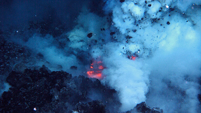
PART-2C: HYDROTHERMAL VENTS AND PLUMES
Weiss, Rudolf Fritz, et al. “Hydrothermal plumes in the Galapagos Rift.” Nature 267.5612 (1977): 600-603. ALTHOUGH there is indirect evidence that a major fraction of the heat loss from newly-created lithosphere occurs by convection of seawater through the porous crust1–3, it has proved difficult to locate vents of deep-sea hydrothermal systems by direct measurement of the discharge fluid. Local increases in bottom water temperature up to 0.1 °C have been measured by towing arrays of thermistors a few metres above the axes of active oceanic spreading centres4,5, but these data are ambiguous because small temperature anomalies may have a hydrographic explanation. We report here the first conclusive measurements of modified seawater discharging as buoyant hydrothermal plumes from fissures in young oceanic crust. We obtained samples of hydrothermal plumes in the Galapagos Rift3, albeit after considerable dilution with surrounding bottom-water, and report the first results of the collection and analysis of these samples.
Isley, Ann E. “Hydrothermal plumes and the delivery of iron to banded iron formation.” The Journal of Geology 103.2 (1995): 169-185. Most of the iron in banded iron formation (BIF) was deposited during the period 2.7-1.8 Ga. Within this period, Fe deposition rates were at least as high as  . According to new age models for the largest BIFs, peak deposition occurred between 2.4-2.3 Ga. It is likely that such high deposition rates would not be met by a solely continental source of iron unless significant quantities were remobilized in marine sediment. Estimates of global heat loss for the Late Archean-Early Proterozoic suggest a hydrothermal cycling rate approximately three times greater than at present, so hydrothermal water-rock exchanges were a more important source of Fe to the oceans than today. Hydro-thermal plumes, depleted in
  and enriched in Fe, were generated at mid-ocean ridge crests with substantially shallower depths than present. Assuming hydrothermal effluent dilution factors of
  , plumes transported iron which had a dominantly hydrothermal source into the upper water column and transferred it to margins where BIFs accumulated. However, unless the quantity of iron liberated during hydrothermal cycling was significantly greater per unit volume of water than today, then either
  of all hydrothermal iron accumulated in the five very large class BIFs, or they also received Fe from continental sources.
Baker, Edward T., Christopher R. German, and Henry Elderfield. “Hydrothermal plumes over spreading-center axes: global distributions and geological inferences.” Geophysical Monograph-American Geophysical Union 91 (1995): 47-47. Hydrothermal plumes, formed by the turbulent mixing of hot vent fluids and ambient seawater, are potent tools for locating, characterizing, and quantifying seafloor hydrothermal discharge. Hydrographic, optical, and chemical tracers have all been used successfully to identify plumes. Observational techniques have progressed from discrete samples collected on vertical casts to continuous, in situ physical and chemical analyses that produce two- and three-dimensional plume maps. We present here a synthesis of available data from spreading centers throughout the world ocean wherever plumes have been mapped on a vent-field, segment, or multisegment scale. About 3% of the global divergent plate margin has been scrutinized for hydrothermal plumes; close to twice that distance has been sampled at least cursorily. Along medium- to superfast-spreading ridges in the eastern Pacific, where the most detailed work has been done, venting is common and plumes overlie 20-60% of the ridge crest length. Plumes are found also wherever careful surveys have been conducted in western Pacific marginal basins. Slow-spreading ridges in the North Atlantic, sampled over greater length scales but in less detail than in the Pacific, appear to have a comparatively low incidence of venting. Little is known of plume distributions over ridges in other oceans. These studies confirm that hydrothermal venting is present across the entire range of spreading rates and that continuous, underway plume surveys are the most efficient means available for locating seafloor discharge sites. Moreover, plume surveys are the only practical approach to mapping hydrothermal discharge patterns over multisegment spatial scales, and to integrating hydrothermal fluxes on a vent-field or larger scale. The plume surveys conducted to date indicate that the incidence of hydrothermal plumes over the ridge axis increases directly with increasing spreading rate. This observation supports models of crustal evolution that predict a direct relationship between the axial hydrothermal heat flux and spreading rate. This conclusion must be tempered, however, by the recognition that most of the global spreading center system remains unexplored for hydrothermal activity.
Lupton, John E. “Hydrothermal plumes: near and far field.” GMS 91 (1995): 317-346. Hydrothermal plumes are a direct result of the thermal and chemical input from submarine hot spring systems into the oceans; consequently plumes hold many clues to the characteristics of hydrothermal venting and its effect on the oceans. Plumes are an important mechanism of dispersal for the thermal and chemical fluxes introduced at seafloor hot springs. Although the details are poorly understood, it is likely that plumes are also important agents in the dispersal of the larvae of hydrothermal vent fauna and may be responsible for the enhancement of pelagic zooplankton biomass. In at least one case, it has been shown that a basin-scale hydrothermal plume traces a major deep ocean circulation cell driven by the buoyancy flux from hydrothermal venting. Finally, because they integrate the hydrothermal input, plumes are valuable tools for a variety of studies of mid-ocean ridges, such as locating active sites of hydrothermal venting, estimating thermal and chemical fluxes from hydrothermal systems, and assessing the magmatic state of the underlying ridge.
Lilley, Marvin D., Richard A. Feely, and John H. Trefry. “Chemical and biochemical transformations in hydrothermal plumes.” GMS 91 (1995): 369-391. Hydrothermal plumes integrate the heat and mass flux originating at seafloor hydrothermal vents thereby providing both a means of detecting hydrothermal activity and estimating hydrothermal fluxes. Many chemical species are introduced into the deep sea via hydrothermal plumes (Figure 1) in concentrations many orders of magnitude higher than that existing in background seawater (e.g. H2, CH4 3He, Mn, Fe) while others are scavenged from seawater by hydrothermal particles (e.g. PO4-3, V, As, rare earth elements, Th). Dilution by entrainment of background seawater in the buoyant portion of the plume is very rapid (see chapters by Lupton and McDuff, this volume) such that the hydrothermal component in the near-field portion of the neutrally buoyant plume represents only about 0.01% of the mixture. Nevertheless, chemical tracers such as 3He, CH4, and Mn are widely utilized in addition to temperature, salinity, and light transmission anomalies to detect hydrothermal venting and to draw inferences about the nature of the underlying geochemistry of the hydrothermal system. Many other chemical tracers can be utilized during plume studies to provide additional information about the nature of the venting. These include particles, H2, Al, and radioisotopes, among others.
German, C. R., Gary P. Klinkhammer, and M. D. Rudnicki. “The Rainbow hydrothermal plume, 36° 15′ N, MAR.” Geophysical research letters 23.21 (1996): 2979-2982. The Rainbow hydrothermal plume was discovered during a recent geophysical survey along 200 km of the Mid‐Atlantic Ridge (MAR), SW of the Azores Triple Junction, in which at least seven new sites of hydrothermal activity were identified. Here, we present the first hydrographic study of the Rainbow plume, 36°15′N, the strongest of the features located during that survey. The plume is detectable from real‐time in situ nephelometer anomalies and extends 10–15km, W‐E, in a non‐transform discontinuity (NTD) between two adjacent ridge‐segments. Maximum anomalies in the Rainbow plume indicate particle enrichments at least as large as those seen directly above the Trans Atlantic Geotraverse (TAG) vent‐field (26°N, MAR). Analysis of hydrographic data indicates a vent source at Rainbow with a thermal output of up to 98 MW, representing 140% of the thermal output previously attributed to TAG. Both lines of evidence indicate the Rainbow plume to be the strongest such feature yet found on the MAR.
Bennett, Sarah A., et al. “The distribution and stabilisation of dissolved Fe in deep-sea hydrothermal plumes.” Earth and Planetary Science Letters 270.3-4 (2008): 157-167. We have conducted a study of hydrothermal plumes overlying the Mid-Atlantic Ridge near 5° S to investigate whether there is a significant export flux of dissolved Fe from hydrothermal venting to the oceans. Our study combined measurements of plume-height Fe concentrations from a series of 6 CTD stations together with studies of dissolved Fe speciation in a subset of those samples. At 2.5 km down plume from the nearest known vent site dissolved Fe concentrations were ∼ 20 nM. This is much higher than would be predicted from a combination of plume dilution and dissolved Fe(II) oxidation rates, but consistent with stabilisation due to the presence of organic Fe complexes and Fe colloids. Using Competitive Ligand Exchange–Cathodic Stripping Voltammetry (CLE–CSV), stabilised dissolved Fe complexes were detected within the dissolved Fe fraction on the edges of one non-buoyant hydrothermal plume with observed ligand concentrations high enough to account for stabilisation of ∼ 4% of the total Fe emitted from the 5° S vent sites. If these results were representative of all hydrothermal systems, submarine venting could provide 12–22% of the global deep-ocean dissolved Fe budget.
PART-2D: HYDROTHERMAL PLUME METHANE
Welhan, JA T., and H. Craig. “Methane and hydrogen in East Pacific Rise hydrothermal fluids.” Geophysical Research Letters 6.11 (1979): 829-831. Recently discovered hydrothermal vents at 21°N on the East Pacific Rise are discharging turbid waters at up to 400°C; mixtures of the plumes with ambient seawater contain significant amounts of dissolved H2 and CH4as well as He. The first grab samples of these waters were diluted 50‐100 foldbut they contained as much as 20 × 10−5 cc(STP) of H2 and 2 × 10⁻⁵ cc(STP) of CH4 per gram of water. H2/CH4 ratios in the vents increase with temperature, a result that is tentatively attributed to chemical equilibrium and/or the redox state of the individual waters. The phase diagram for the NaCl‐H2O “surrogate‐seawater” system shows that liquid‐vapor separation may take place prior to discharge and mixing of a vapor phase with entrained cooler sea‐water would profoundly alter original concentrations of volatiles as well as dissolved salts. H2 and CH4 ratios to basalt‐derived helium are respectively about 550 and 70 in these waters. The total fluxes from the world‐ocean ridge system estimated from the He‐3 flux are of the order of 1.3 × 10⁹ m³/y for H2 and 1.6 × 10⁸ m³/y for CH4. The CH4 flux so calculated is sufficient to replace the deep‐sea methane in ∼ 30 years implying a very rapid bacterial consumption rate below the thermocline.
De Angelis, M. A., M. D. Lilley, and J. A. Baross. “Methane oxidation in deep-sea hydrothermal plumes of the Endeavour Segment of the Juan de Fuca Ridge.” Deep Sea Research Part I: Oceanographic Research Papers 40.6 (1993): 1169-1186. Methane oxidation rates were measured in samples from a deep-sea lateral hydrothermal plume generated from a vent field on the Endeavour Segment of the Juan de Fuca Ridge. Specific CH4 oxidation rates of up to 0.15 day−1, corresponding to turnover times on the order of 1 week, are the highest such rates so far reported for the water column of any marine environment. Specific methane oxidation rates within the plume were found to be highest at distances of 2–5 k downplume from the vent field of origin. Ambient CH4 oxidation rates were highest in the lateral plume immediately above the vent field where CH4 concentrations were maximal. Methane oxidation rates appeared to be sufficient to account for the majority of CH4 loss in the plume which could not be attributed to dilution. Oxidation of vent-derived CH4 within the lateral plume can contribute an amount of organic carbon equivalent to up to 150% of that reaching the depth of the plume from surface primary production, suggesting that microbial CH4 oxidation can have a significant impact on local deep-sea productivity in the immediate vicinity of oceanic spreading centers.
Charlou, Jean‐Luc, and Jean‐Pierre Donval. “Hydrothermal methane venting between 12° N and 26° N along the Mid‐Atlantic Ridge.” Journal of Geophysical Research: Solid Earth 98.B6 (1993): 9625-9642. Hydrographic surveys along the Mid‐Atlantic Ridge (MAR) between 12°N and 26°N, carried out from 1984 to 1990, show a variable pattern of CH4‐rich water column plumes. The vertical distribution of CH4 at stations located every 20–40 km is presented along this 1200‐km‐long section of the MAR. CH4 venting is clearly demonstrated. CH4‐enriched fluids rise from vents as plumes; spreading is confined to the axial valley due to the topography of the MAR. CH4 contents from 45 nmol to 675 nmol/kg are measured in the buoyant plumes above the two active hydrothermal sites (MARK 23°N; TAG 26°N) known at present, whereas CH4 anomalies up to 3.6 nmol/kg are typically observed in plumes emitted either on the inner floor, on the walls, and/or at the top of the rift mountains along the studied ridge section. CH4 concentrations (45 μmol to 144 μmol/kg) in MARK and TAG vent fluids are of the same order of magnitude as those found in the East Pacific Rise fluids. Even though CH4 is known to be unstable with respect to oxidation by dissolved oxygen, and in spite of its microbial oxidation in plumes, these results confirm CH4 to be a good indicator to track hydrothermal plumes and to map the variation of hydrothermal activity along mid oceanic ridges. Moreover, between 12° and 26°N along the MAR, CH4 results show that while hydrothermal activity is present everywhere along the ridge, it is predominant near fracture zones (FZ) (Kane FZ, 15°20′N FZ). Comparison of CH4 tracer with total dissolvable manganese (TDM) tracer in plumes allows us to differentiate subseafloor hydrothermal processes. The high TDM/CH4 found above TAG and MARK areas is indicative of basalt‐seawater interaction, while at 15°N the low TDM/CH4 provides evidence of fluid circulation in ultrabasic rocks. CH4 data confirm the association between mantle degassing, hydrothermal activity, and serpentinization along this 12°–26°N section of the Mid‐Atlantic Ridge.
Mottl, Michael J., et al. “Manganese and methane in hydrothermal plumes along the East Pacific Rise, 8 40′ to 11 50′ N.” Geochimica et Cosmochimica Acta 59.20 (1995): 4147-4165. In November, 1991, we surveyed the water column for hydrothermal plumes along 350 km of the East Pacific Rise axis from 8°40′ to 11°50′N, using a combination of physical and chemical measurements. Our survey included the two major ridge segments north and south of the Clipperton Transform Fault at about 10°10′N, both limbs of the overlapping spreading centers (OSC’s) at 9°03′N and 11°45′N, and a 30-km section of the next ridge segment to the south. We found vigorous plumes along most of this ridge axis, in keeping with its magmatically robust cross-section, axial summit caldera, and shallow, magma-related seismic reflector. These plumes were detectable by both physical (temperature and light attenuation) and chemical (dissolved Mn and CH4) measurements, although the chemical measurements were more sensitive. The least active sections were the southern third of the northern segment from 10°20 to 52′N and the OSCs, especially the OSC at 11°45′N. Plumes there had weak Mn and CH4 signals and were barely detectable by physical methods. These axial sections were the only ones surveyed that lie deeper than 2600 m and appear to be magma starved. The most active sections on the northern segment gave stronger signals for Mn and temperature than for CH4 and light attenuation, whereas the opposite was true on the southern segment, which was the site of a volcanic eruption at 9°45–52′N only seven months prior to our cruise. On the northern segment the four physical and chemical plume tracers correlated positively and linearly with one another, suggesting that the segment was fed by relatively uniform end-member fluids with a mean CH4Mn molar ratio of 0.075. The southernmost section surveyed, from 8°42′ to 9°08′N, closely resembled the northern segment. The rest of the southern segment fell into three sections with different CH4Mn ratios: 9°39 to 53′N with CH4Mn as high as 10, 9°08 to 39′N with CH4Mn of 0.51, and 9°53′ to 10°07′N with CH4Mn of 0.85. The section with the highest CH4Mn was the site of the volcanic eruption, which produced high-temperature, low-salinity, gas-rich vent fluids carrying abundant bacterial particles. The high CH4 concentrations are clearly associated with the volcanic eruption, but the origin of the CH4 is unclear.
Tsunogai, Urumu, et al. “Carbon isotopic distribution of methane in deep-sea hydrothermal plume, Myojin Knoll Caldera, Izu-Bonin arc: implications for microbial methane oxidation in the oceans and applications to heat flux estimation.” Geochimica et Cosmochimica Acta 64.14 (2000): 2439-2452. The concentration and stable carbon isotopic composition (δ13C) of methane have been measured for both seafloor hydrothermal venting fluids and effluent plume waters supplied from the vents at the Myojin Knoll Caldera, Izu-Bonin arc, in the western North Pacific. The hydrothermal end-member concentrations and δ13C of methane show near-homogeneity among vents: 41.2 (μmol/kg) and −16.3 ± 0.8 (‰PDB), respectively, while those in the effluent plume are stratified in the caldera and vertically exhibit a large variation (2.1–11 (nmol/kg) and −29.0 to −11.3 (‰PDB), respectively). Comparison of concentration and δ13C data between vent fluids and plume waters suggest that the methane is not conserved but microbially oxidized along with the plume. Gradual decrease of diffusive methane flux in proportion to distance from the vent fields supports the occurrence of significant microbial oxidation within the plume. Assuming steady state emission of methane from the vents, (1) kinetic isotope effect due to the microbial oxidation (k12/k13); (2) methane flux from the vents (Fvents); (3) heat flux from the vents (Q); and (4) average turnover time of hydrothermal methane (Tall) are estimated to be k12/k13 = 1.005 ± 0.001, Fvents = 90–340 (mol/d), Q = 30–110 (MW), and Tall = 60–240 (d), respectively. The estimated turnover times, however, are not uniform within the water column. Around the vents, a turnover time of less than 50 d for methane is one of the shortest values in the pelagic ocean, while those at the distant points correspond to values more typical for deep ocean water.
Cowen, James P., Xiyuan Wen, and Brian N. Popp. “Methane in aging hydrothermal plumes.” Geochimica et Cosmochimica Acta 66.20 (2002): 3563-3571. Methane concentration and the stable carbon isotopic composition (δ 13C–CH4) were measured in aging hydrothermal plume waters originating at the Endeavour Segment, Juan de Fuca Ridge. CH4 concentrations decreased systematically from 600 nM at on-axis stations to <11 nM at a distal station 15 km off axis; background CH4 concentrations are <2 nM. CH4 behaves nonconservatively in plume waters and does not correlate with conservative parameters such as temperature anomaly (Δθ), but is highly correlated with NH4+ and total dissolvable Mn. δ 13C–CH4 values for plume depth samples varies inversely and significantly (R2 = 0.89) with methane concentrations normalized to Δθ. Some δ 13C–CH4 values (+1.8 and +10.9 ‰) measured at the 15 km off-axis station are among the heaviest yet reported from a natural marine environment. Less than 5% of original hydrothermal methane remains in the plume at this station. The data are consistent with extensive microbial methane oxidation. A narrow range of fractionation factors (rc ≈1.0072 to 1.0077) was calculated for the Endeavour samples. These fractionation factors are less than those reported by Coleman et al. (1981), but fall near the trend line of their rc versus temperature data when extrapolated to plume water temperature (∼2 °C).
Kawagucci, Shinsuke, et al. “Methane, manganese, and helium‐3 in newly discovered hydrothermal plumes over the Central Indian Ridge, 18°–20° S.” Geochemistry, Geophysics, Geosystems 9.10 (2008). We have investigated newly discovered submarine hydrothermal plumes over the Central Indian Ridge, 18°–20°S. Onshore chemical analyses of methane, its carbon isotope, manganese, and helium‐3 in seawater samples obtained from the plumes revealed their detailed geochemical characteristics. One of the newly discovered hydrothermal plumes located over the western wall of the axial valley at Segment 15B (19°33′S), called the Roger Plateau, showed constant CH4/Mn and CH4/3He ratios throughout the plume. The CH4/3He ratio (4 × 10⁶) and δ13C (−17.5‰) are consistent with those of basalt‐hosted sediment‐free hydrothermal systems, although the CH4/Mn ratio (∼1) is moderately higher. These features are thought to indicate a metal‐depleted fluid chemistry. The other hydrothermal field is located within the axial valley at the northern part of the smooth lava plain at Segment 16 (18°20′S), called the Dodo Great Lava Plain, where several plumes were detected. The CH4/Mn and CH4/3He ratios showed large variation through the plumes while δ13C values were almost constant. Geochemical characteristics of venting fluid estimated from those of the plumes were apparently high CH4/Mn (>6) and CH4/3He (>60 × 106) ratios and low δ13C values (<−27.5‰), suggesting possible influences of several methane input processes to the fluid chemistry.
Wen, Hsin-Yi, et al. “Helium and methane sources and fluxes of shallow submarine hydrothermal plumes near the Tokara Islands, Southern Japan.” Scientific reports 6.1 (2016): 1-9. Shallow submarine volcanoes have been newly discovered near the Tokara Islands, which are situated at the volcanic front of the northern Ryukyu Arc in southern Japan. Here, we report for the first time the volatile geochemistry of shallow hydrothermal plumes, which were sampled using a CTD-RMS system after analyzing water column images collected by multi-beam echo sounder surveys. These surveys were performed during the research cruise KS-14-10 of the R/V Shinsei Maru in a region stretching from the Wakamiko Crater to the Tokara Islands. The 3He flux and methane flux in the investigated area are estimated to be (0.99–2.6) × 104 atoms/cm2/sec and 6–60 t/yr, respectively. The methane in the region of the Tokara Islands is a mix between abiotic methane similar to that found in the East Pacific Rise and thermogenic one. Methane at the Wakamiko Crater is of abiotic origin but affected by isotopic fractionation through rapid microbial oxidation. The helium isotopes suggest the presence of subduction-type mantle helium at the Wakamiko Crater, while a larger crustal component is found close to the Tokara Islands. This suggests that the Tokara Islands submarine volcanoes are a key feature of the transition zone between the volcanic front and the spreading back-arc basin.
Levin, Lisa A., et al. “Hydrothermal vents and methane seeps: rethinking the sphere of influence.” Frontiers in Marine Science 3 (2016): 72. Although initially viewed as oases within a barren deep ocean, hydrothermal vents and methane seep chemosynthetic communities are now recognized to interact with surrounding ecosystems on the sea floor and in the water column, and to affect global geochemical cycles. The importance of understanding these interactions is growing as the potential rises for disturbance of the systems from oil and gas extraction, seabed mining and bottom trawling. Here we synthesize current knowledge of the nature, extent and time and space scales of vent and seep interactions with background systems. We document an expanded footprint beyond the site of local venting or seepage with respect to elemental cycling and energy flux, habitat use, trophic interactions, and connectivity. Heat and energy are released, global biogeochemical and elemental cycles are modified, and particulates are transported widely in plumes. Hard and biotic substrates produced at vents and seeps are used by “benthic background” fauna for attachment substrata, shelter, and access to food via grazing or through position in the current, while particulates and fluid fluxes modify planktonic microbial communities. Chemosynthetic production provides nutrition to a host of benthic and planktonic heterotrophic background species through multiple horizontal and vertical transfer pathways assisted by flow, gamete release, animal movements, and succession, but these pathways remain poorly known. Shared species, genera and families indicate that ecological and evolutionary connectivity exists among vents, seeps, organic falls and background communities in the deep sea; the genetic linkages with inactive vents and seeps and background assemblages however, are practically unstudied. The waning of venting or seepage activity generates major transitions in space and time that create links to surrounding ecosystems, often with identifiable ecotones or successional stages. The nature of all these interactions is dependent on water depth, as well as regional oceanography and biodiversity. Many ecosystem services are associated with the interactions and transitions between chemosynthetic and background ecosystems, for example carbon cycling and sequestration, fisheries production, and a host of non-market and cultural services. The quantification of the sphere of influence of vents and seeps could be beneficial to better management of deep-sea environments in the face of growing industrialization.
Our oceans may have six times as many hydrothermal vents as thought
By Ben PankoJun. 21, 2016 , 5:15 PM: LINK: https://www.sciencemag.org/news/2016/06/our-oceans-may-have-six-times-many-hydrothermal-vents-thought Hydrothermal vents, cracks in Earth from which hot water spews, may be far more numerous than scientists realized: three to six times more numerous, Science News reports. To find them, oceanographers hunted for chemicals released by the vents in areas called spreading ridges, where the ocean floor is literally pulling apart. The team found 184 hydrothermal vents for 1470 kilometers of ocean floor, or one vent every 2 to 20 kilometers, according to research published online in Earth and Planetary Science Letters. That’s far greater than the one vent for every 12 to 220 kilometers that used to be the norm, they reported. Because these vents are vital habitats for deep-sea flora and fauna, this discovery likely increases the number of areas to search for underwater life.
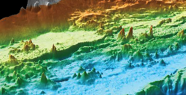
ONLINE ARTICLE ON GLOBAL DISTRIBUTION OF HYDROTHERMAL VENTS BY HARRY BAKER WITH DATA FROM THE MONTEREY BAY AQUARIUM RESEARCH INSTITUTE: MBARI.ORG . LINK TO HARRY BAKER: https://marinemadness.blog/2020/06/12/new-map-gives-us-our-best-look-yet-at-hydrothermal-vents/
THE HARRY BAKER ARTICLE: {Note: The Endeavour Segment is a vent field in the Northeast Pacific.} A new paper by researchers from MBARI.ORG has revealed a large extent of the famous Endeavour Segment of hydrothermal vents. The high resolution map of 572 chimneys has changed what we know about this region and hydrothermal vents in general, as well as opening up new possibilities for researchers. Hydrothermal vents are one of the most important and least understood habitats in the deep sea. This is primarily because they can be extremely hard to locate thousands of metres beneath the surface. For years one of the best places to study hydrothermal vents has been the Endeavour Segment, a field of deep sea chimneys located around 350 kilometres Northwest of Washington State. However new research carried out by a group of researchers from MBARI (Monterey Bay Aquarium Research Institute) has revealed that there are far more vents there than previously thought, with a total of 572 chimneys mapped by an AUV. Not only has this changed what we know about hydrothermal vents in this area, but also in general, as well as providing researchers with a new way of finding and studying them. What are hydrothermal vents? Hydrothermal vents occur at places in the deep ocean where magma below the seafloor superheats the water that seeps down through the bedrock. This superheated water is then pushed back through the seafloor, absorbing metals and minerals from its surroundings as it goes. When the boiling hot water penetrates the seafloor and mixes with the freezing waters of the deep oceans, it causes the metals and minerals in the water to condense and forms underwater structures or chimneys that continue to pump out the superheated water into the ocean. Hydrothermal vents are biodiversity hotspots in the deep ocean thanks to creatures like these tubeworms that convert the sulphur they produce into energy. These chimneys habitats for deep sea ecosystems because they are surrounded by specially adapted creatures with high thermal tolerance, some of which have the ability to convert the sulphur they produce into energy. This means that vents are very important to the deep sea food web where life does not derive from sunlight. Hydrothermal vents are also a major candidate for the birthplace of life on Earth billions of years ago. Today they are also financially valuable due to the accumulation of valuable metals that make up the chimneys and are targeted by destructive deep sea mining companies. The Endeavour Segment has beed a focal point for vent research because of its high volcanic activity. The seafloor has very literally been ripped apart by this activity over the last few thousand years and provided places for multiple vents and chimneys to grow. It has been constantly surveyed by submersibles and underwater robots since 1982 and as a result researchers believed there were between 45 and 60 vents, one of which ‘Godzilla’ grew to 45m tall before toppling in 1995, all located in a long narrow valley about 14km long and 1.5km wide. However due to poor visibility, total darkness and limited technology, it was hard to determine the exact number for certain. To finally determine how many vents were in the Endeavour Segment, MBARI mapped the field with sonar using their AUV (Autonimus Underwater Vehicle) at just 50m above the seafloor. The result was a new map with a resolution of 1.25 metres that showed not just 45-60 vents, but an incredible 572. The map and other results from the survey were recently published by the MBARI team in a new paper in the journal AGU. These results came as a surprise to many researchers because they had grossly underestimated the number of hydrothermal vents in the Endeavour Segment. However a large portion of these vents are actually inactive. Compared to other areas mapped by MBARI, such as the Alcon Rise in the Gulf of California, the endeavour segment has a much higher percentage of chimneys that no longer funnel superheated water. This is something that eventually happens to all hydrothermal vents over time as there is a build-up of minerals and metals that clog up the water flow. However the large proportion of them in this one location has sparked a new theory about hydrothermal vents. In their new paper the MBARI team suggest that the reason the Endeavour segment has so many sleeping chimneys is because despite its history of high volcanic activity, it is actually starting to become much less active. They propose that the reason areas like the Alcon Rise have fewer vents but more active ones, is that they are in a different period of volcanic activity. Because of this they have also proposed a new life-cycle of hydrothermal vent fields wirh three main stages…
- A magmatic phase, lasting up to tens of thousands of years, when large amounts of magma erupt and cover the seafloor with lava.
- A tectonic phase, lasting perhaps 5,000 years, when the magma supply slows, and the seafloor cools and contracts.
- A hydrothermal phase, lasting just a few thousand years, when resurgent magma below the surface heats fluids that percolate upwards through seafloor cracks, forming large numbers of vents.
By following MBARI’s example we can now study hydrothermal vent fields in much greater detail and maybe even find new sites for their research. Hopefully this means that over the next few decades we will be able to uncover more of their secrets and gain a better understanding of deep-sea habitats and ecosystems, which will enable us to better protect them.